Last year I started looking into the history of the area I grew up in at the bottom of the Glen Road. My initial interest was naming and tracing the dirty old river that flows under Miller’s Grove (formerly MacErlean’s bakery) at the top of Upton Cottages.
Turf Lodge Stream, as I would soon learn it was called, was a childhood playground for everyone in our street, Arizona Street, when I was growing up in the 1980s. Long summer nights were spent playing around it, catching frogs and watching rats disappear under the bakery while we stood on the two broad planks that formed the bridge across it. However, what started for me as just a bit of nostalgic curiosity has led, through old maps and texts, to the rediscovery of the area’s long-forgotten placename. The lost townland name of Ballycranocke hasn’t been recorded anywhere for over 100 years, yet I am almost certain that it lives on to the present day in the name of Lake Glen.
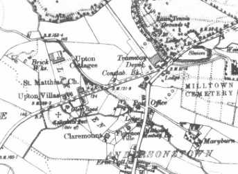
Something that had always interested me was Callender’s Fort, an ancient settlement that was said to have been located around the bottom of the Glen Road. It was easily forgotten as the residential areas of the Glen Road sprung up in the middle of the 20th Century, and the few modern references that were made to the medieval fort never seemed to mention its exact location. It was even said at one point that it might have been under the site of the former Andersonstown RUC Barracks at the bottom of the road. Early on while looking into the Turf Lodge Stream I was able to confirm the exact location of Callender’s Fort. Every map I could find showed that it was near the bottom of Arizona Street, in fact directly facing the Gransha Shops. This was backed up by the source most commonly used by local historians, Monsignor James O’Laverty’s ‘History of the Diocese of Down & Connor’. Writing in 1878, O’Laverty stated that the fort was “on the left side of the road leading from the New Catholic Cemetery of Milltown to the Hannahstown Police Barrack, and about 100 perches from the cemetery”. I decided to find out more about the fort and in particular the origin of its peculiar name.
O’Laverty described the fort as a “green knoll... which is known to have been the site of a church.” He also mentions the huge amounts of human bones that were exposed when the route of the Glen Road was being cut out through the site. His description relies heavily on the 1847 account by Bishop William Reeves of the ‘Ecclesiastical Antiquities of Down, Connor and Dromore’. However, inexplicably, O’Laverty repeats a misunderstanding that Reeves’ account had actually set out to clarify 30 years earlier. Reeves pointed out that the names of two old churches and their associated placenames had been mixed-up at some point in time and that this left us without an exact identification of either in the ecclesiastical record. The Church of Croockmock in Ballycromoake (Cromac) and the Church of Cranoge in Ballycranocke “in the Tuogh Fall” had to be two separate entities Reeves said, and he went on to describe the location of Callender’s Fort “in an angle formed by the branching of the Collin (Glen) Road from the Falls Road, and close to the left side of the former”. Yet 30 years later, and despite another account by Reeves and two other histories written before Reeves also clearly affirming his opinion that the two were separate, Monsignor O’Laverty would for some reason repeat the mistake and declare that the Callender’s Fort site was the location of the Church of Ballycromoake/Crookmock. Reeves was explicit about the location of Ballycranocke in a 1860 pamphlet that was reprinted in 1903, confirming that it was where Callender’s fort lay within the townland of Ballymurphy. However, the result of the confusion sewn by Monsignor O’Laverty was that the name and location of Ballycranocke, as well as its significance for the church and fort on the Glen Road, was lost entirely for the last 100 years. Subsequent accounts of Callender’s Fort, of which there are very few, relied almost entirely on O’Laverty’s text or versions of it. The most notable of these is the 1940s account by the renowned Belfast writer, Cathal O’Byrne.
In describing the site of the ancient church at Callender’s Fort, Bishop Reeves said that “[t]he surrounding space is stated to have been occupied by a burying ground”. O’Laverty of course also mentioned the graves that were disturbed there when the Glen Road was being laid out. Cathal O’Byrne claimed to have a local source who told him that “[t]he word Callender is probably a corruption of the Gaelic word, Calluragh – an old graveyard.” The word ceallúrach still exists in Irish as a children’s burial ground. In fact, some features of this site make it an ideal location for a cillín which was a burial site for un-baptised children or some other individuals who were deemed unfit to be buried in a conventional, consecrated church graveyard. Used up to the early 20th century in parts of Ireland, with several examples in county Antrim, these were typically located at natural landmarks, ditches, townland boundaries and just outside church graveyards or inside deserted church grounds. Callender’s Fort had all of these characteristics: an old church beside a distinctive mound surrounded by streams and ditches right on the border between the townlands of Ballydownfine and Ballymurphy (the border of these two townlands is still marked with old Blefast Corporation town boundary markers at the bottom of Andersonstown Park and on the Glen Road at the Gransha Shops). Furthermore, variations of the old word for a cillín include cealltrach and even caldragh. Callender, therefore, is almost certainly an Anglicisation of caldragh meaning a cillín or burial ground for un-baptised children and for those unfortunates who found themselves on the fringes of society.
The earliest reference to Callender’s Fort is in ‘The Terrier’, a 1615 ledger book containing details of all of the religious buildings in Down and Connor. It notes “Callender’s Fort, in Falls” as the location of a church which it names in two different ways. One name recorded is Cappella de (Church of) Killeroi, which is clearly a variant of ceallúrach and strengthens O’Byrne’s contention about the origin of Callender. The other name for the church as recorded in the Terrier is Capella de Cranoge. The entire entry about this church seems to have been removed from some copies of the Terrier and, whatever of the cause for this (which is interesting to speculate about in itself), this partial omission could well be the root cause of much of the confusion that ensued around the different churches of Cromoake and Cranocke. In any case, this clear recording in the Terrier not only confirms the location of the ancient church at this future Glen road site; it establishes this name of Cranoge as being of significance to that particular area.
In all of the maps of the area I had looked at, dating from the middle of the 19th century, two things struck me: first was that the name Lake Glen was clearly marked as referring not only to the site of the future housing development but to the entire area enclosed between the two branches of the Turf Lodge Stream, including what would in later times become Upton Cottages, Arizona Street and Lake Glen itself; the other thing was that there was no lake! Even earlier maps going back to 1800 showed no sign whatsoever of a lake or any significant body of water in the vicinity. So why Lake Glen?
Cathal O’Byrne provides a clue: “Lake Glen in the old days contained a lake with a crannog at the centre.” I have spoken to a number of residents who told me there was a lake in Lake Glen but when I presented them with the evidence of the maps (ie showing that there was no lake) they said they had merely been told that there was, and that they only remember rivers that flowed down past the small cottage in the field there. I believe the existence of a lake in this area is a myth that owes its existence to the name Ballycranocke. Ballycranocke comes from the Irish Baile Crannóige – meaning either ‘place with a crannóg/small wooden dwelling, usually in or near a lake’, or, alternatively, ‘place abundant in trees or where there is a young plantation’.
George Benn in his ‘History of Belfast’, written in 1823, favoured the latter interpretation. Describing the town’s religious buildings, he said: “Of the other religious edifices which formerly belonged to this parish, the principal was situated about two miles from Belfast, near the present Falls Road. It is said to have been called Crannog, which signifies the young plantation.” The other possibility is that there was in fact a small, perhaps wooden dwelling there for a long time, which may have simply been surrounded by the various streams in the vicinity. This could have earned it the name of crannóg. There could even have been a turlough that formed at different times of the year, which is where an area like this can flood and form a temporary lake-like body of water. The fact that there was a small cottage at the bottom of Lake Glen where it meets the Falls Road, as well as the fact that the first address recorded in the area in 1874 was Lake Glen Cottage, would appear to support this interpretation. One other strong possibility was that Callender’s Fort itself, which more than likely had some sort of wooden structures at one time, was the crannóg. It was surrounded on three of its four sides by streams (including the branch of our Turf Lodge Stream that formed the line along which Arizona Street was built), and these could easily have been used to provide defence against attack – another common feature of a crannóg. Writing in 1860, Reeves said that the Capella de Cranoge at Callender’s Fort “probably derived its name from its occupying a site once artificially formed in marshy ground.”
Whatever the origin, it is likely that the element ‘crannóg’ in the old placename of Ballycranocke led local people (or perhaps even a town planner or cartographer) to invent the name Lake Glen in the early 19th Century because the existence of a lake was long associated with the name crannóg. The numerous waterways of varying size that flowed down towards the Falls Road through the sloping land that lay around the ancient fort – or indeed the occasional presence of a turlough-type body of water – may have seemed to further justify such a designation. One of the first houses on the Glen Road, in what would become Arizona Street, was Glendalough, which ironically appears to be a re-interpretation back in to Irish of ‘Glen of the Lake’. What seems clear therefore is that the name Lake Glen originates in the Irish crannóg and that we can link this historical area of Lake Glen including both sides of the lower Glen Road with the lost placename of Ballycranocke.
The only existing official recorded use of the Ballycranocke placename was at an Inquisition for James I, taken at Antrim in 1605. Apart from that we have Bishop Reeve’s clues in his 1847 and 1860 accounts where he lamented that the name “is now lost”. I like to think Ballycrannock/Baile (na) Crannóige remains alive in the name of Lake Glen, which comes from this ancient Irish placename for the area around the church and fort on the border between Ballymurphy and Ballydownfine. Both it and the origin of the name of the fort itself (caldragh or ceallúrach, meaning burial site) reminds us as well that the Irish language surrounds us in our heritage and in the history of the land with which it is inextricably linked.