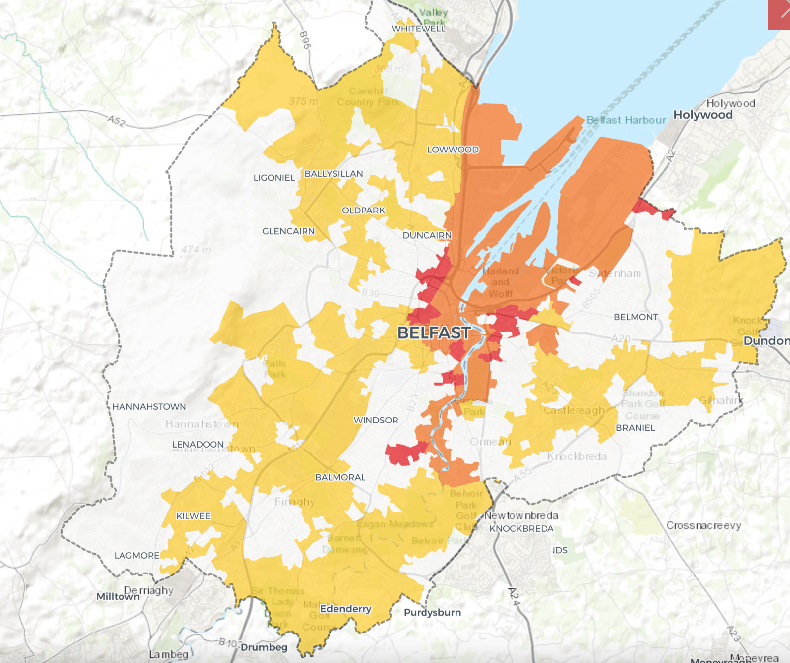
AN interactive map that identifies public land and resources for tackling the city's housing crisis and climate change has revealed that extensive parts of Belfast are at risk of flooding by 2080.
Developed by the Take Back the City Coalition, the toolkit marks the locations of available land and property, and maps out ownership and potential for sustainable development. It also identifies green infrastructure such as street trees, cycle lanes and bicycle stations.
The Take Back the City Coalition is a partnership between Build Homes Now campaign, Queens University School of Architecture, Participation and the Practice of Rights (PPR), The Town and Country Planning Association, Rabble Tech Cooperative and award-winning author, Rory Hearne,

Using data from the Department of Infrastructure (DfI) and the scientist-led research organisation, Climate Central, the Coalition has mapped the river and tidal flood threat across Belfast.
Climate Central's projections are for tidal flooding linked to temperature increases of 1.5 to three degrees celsius due to global warming. Meanwhile, DfI has produced climate change maps which “highlight the estimated floodplains for the year 2080", which it says "are based on the best available predictions for the meteorological conditions and sea levels for that time."
Areas marked in yellow, including much of West Belfast, indicate a river flood threat, while areas marked in red indicate flooding from rising sea levels. Orange indicates that an area is at risk from both tidal and river flooding.
If indications are correct, much of the inner city, including parts of Divis, New Lodge, Short Stand and the Market could be under water sea level within a lifetime.
In West Belfast, the entirety of the Falls Road is at risk of river flooding, as are parts of the surrounding areas including the Grosvenor, Clonard, and the Royal Victorial Hospital.
The Upper Springfield – parts of the Whiterock, Moyard, Dermott Hill, New Barnsley, and Ballymurphy – are also threatened.
Addresses in Andersonstown, Turf Lodge, Gransha, Ladybrook, Blacks Road and Twinbrook are marked in yellow. Also marked yellow are Oldpark, Ballysillan and Ligoniel.
Marissa McMahon from PPR said information from DfI was retrieved at cost to campaigners.
Commenting on the data, she said: "This information should be public knowledge.
"I would ideally like to know if my daughter is going to survive a flood in 15 years time."
In launching the map, the coalition will also unveil a masterplan for the former Mackie's Site in West Belfast. The 12.7 hectare site is identified as the largest disused site in public ownership in Belfast and, according to the map, escapes the 2080 flood risk.
Campaigners say the site could hold 953 environmentally sustainable homes.
"When we're talking about building at Mackie's, we're not just talking about putting up a load of houses with no amenities," Ms McMahon said.
"What's more important is that these houses stand the test of time in terms of climate change."
To view the Take Back the City Coalition map click here.