GREATER ACCESS to the Belfast Hills has taken a step further after Belfast City Council’s People and Communities Committee approved a motion by People Before Profit Councillor Matt Collins to endorse a report by the Belfast Hills Access Campaign.
The report outlines four routes which the group hope would provide greater access to the hills for residents living in North and West Belfast. It is hoped that if these routes are completed that it would reduce problems associated with accessing the hills via car such as the parking issues that we have seen in recent months.
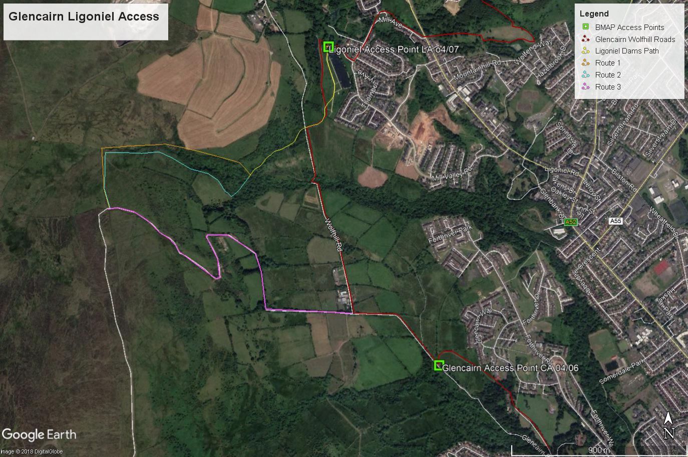
The first proposal is a link from Glencairn and Ligoniel to Divis Mountain. The report details how there are existing access points listed at Glencairn and Ligoniel in the Belfast Metropolitan Area Plan (BMAP) and the draft Local Development Plan, though they currently lead nowhere.


In the absence of the completion of the Ulster Way route it would enable a full walking route across the hills and it would enable ‘half the hills’ walks from either the southern or northern ends terminating at Glencairn or Ligoniel.
The report continues to detail how the Ligoniel Improvement Association has planning permission for an environmental centre at their Dams site which would have facilities for walkers and which could be marketed as ‘The Gateway to the Hills’.
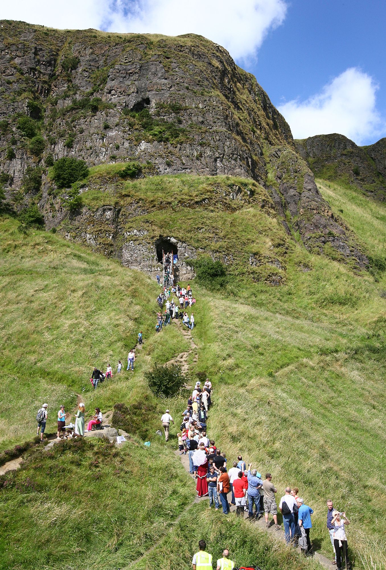
VISION: Walkers on Napoleon's Nose atop Cave Hill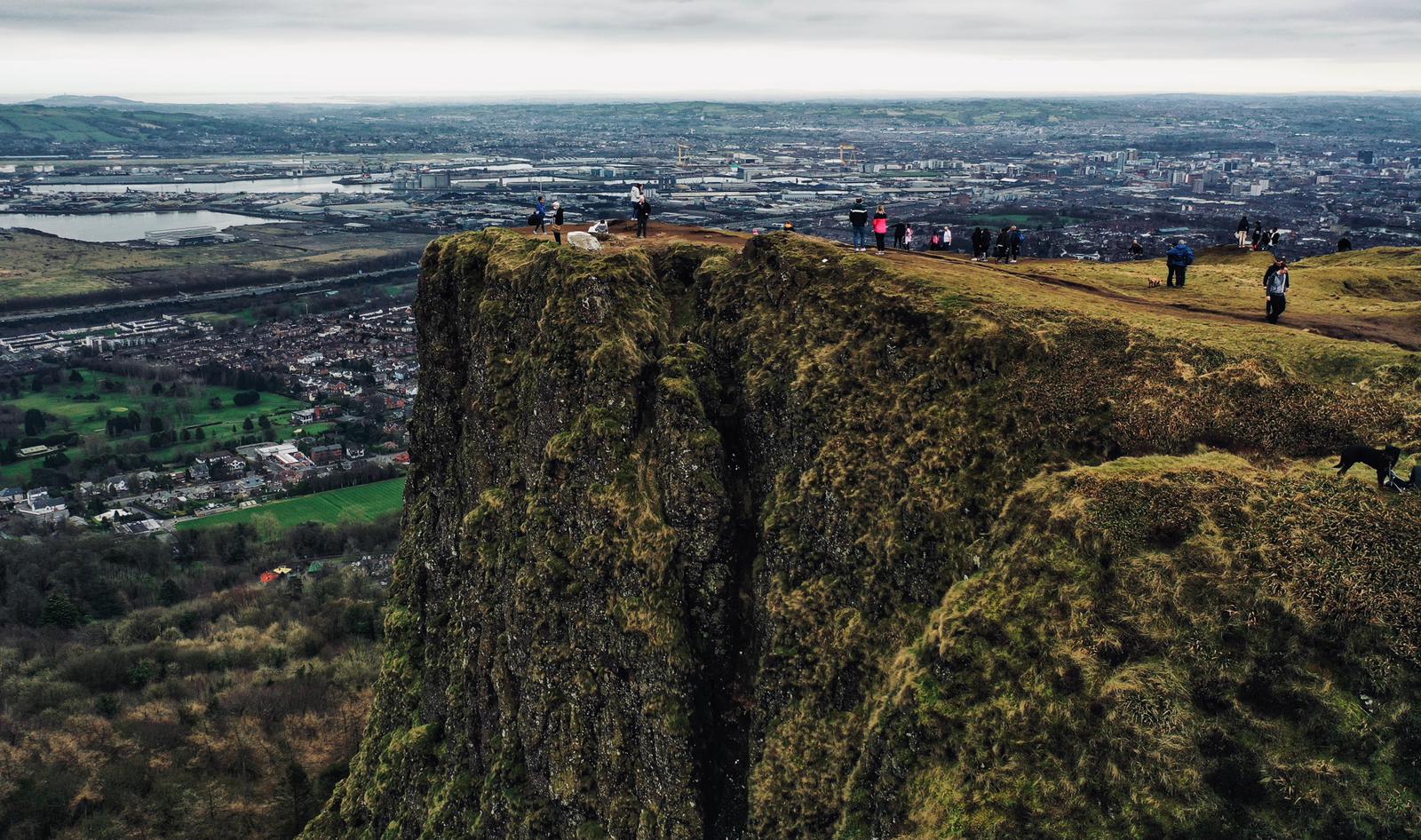
The link would also provide the continuation of the urban greenway proposal for a Forth River/Glencairn/Ligoniel Route, and is also envisaged in the Shankill Greenway proposal for a route running from Peter’s Hill to the Belfast Hills.
There are three options contained within the report for this route. The first, outlined in yellow would lead from a mid-point on the path beside the mill race leading to Ligoniel Dams, and then directly uphill to the north of the Forth River.
The route is one kilometre in length and is the shortest of the three options. Some path construction would be required and it would cross grazing land.
This route would provide the most direct access to the hills from Ligoniel, and a less roundabout route for those hoping to complete a full Belfast Hills Walk. It would provide equally good access from Glencairn via Wolfhill Road and the mill race path. Walkers from Glencairn would not have to go into Ligoniel.

The second route would lead along the path beside the mill race leading to Ligoniel Dams, would bridge the Forth River and then proceed directly uphill to the south of the Forth River. The route is 1.04km in length and like the first proposal, this crosses grazing land and some path construction would be required.
The final route is a continuation on a private farm road off Glencairn Road. The link with Ligoniel would be via Wolfhill Road and the mill race path leading to Ligoniel Dams. This route is 1.37km and is longer than the others but as it is mainly on an existing farm road little path construction would be required.
@BBCNewsNI beautiful day on the Belfast hills this morning. pic.twitter.com/4dLwfR3msa
— fra grogan (@garganite51) March 16, 2021
The report details how this route is preferred because although it involves significantly more roundabout access for Ligoniel and for those undertaking a full Belfast Hills walk, it can make use of the existing roadway through the relevant farmland.
The report also details a number of proposals to connect Whiterock to the Black Mountain. A link from here to the Black Mountain is of vital importance as there is no current right of way from anywhere in West Belfast to the high hills.
This route would link with what is described as the Milltown Urban Landscape Wedge connecting Whiterock with the St James’ area and Lower Andersonstown, and would provide the obvious continuation to the proposed Lagan Valley Regional Park/ Bog Meadows/Whiterock Greenway.
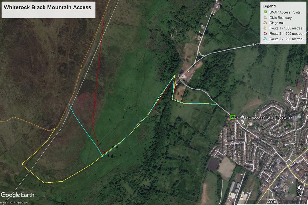
The first route in this proposal has historically been seen as an assumed right of way by the local community. It runs from the top of the Whiterock Road, follows an obvious oblique line up the hillside to the Black Mountain. This is the preferred route though complexities of land ownership may cause problems.
The second proposal is the shortest route and the steepest one climbing the hillside directly and the third proposal climbs the hill obliquely to the north and is longer than the second.
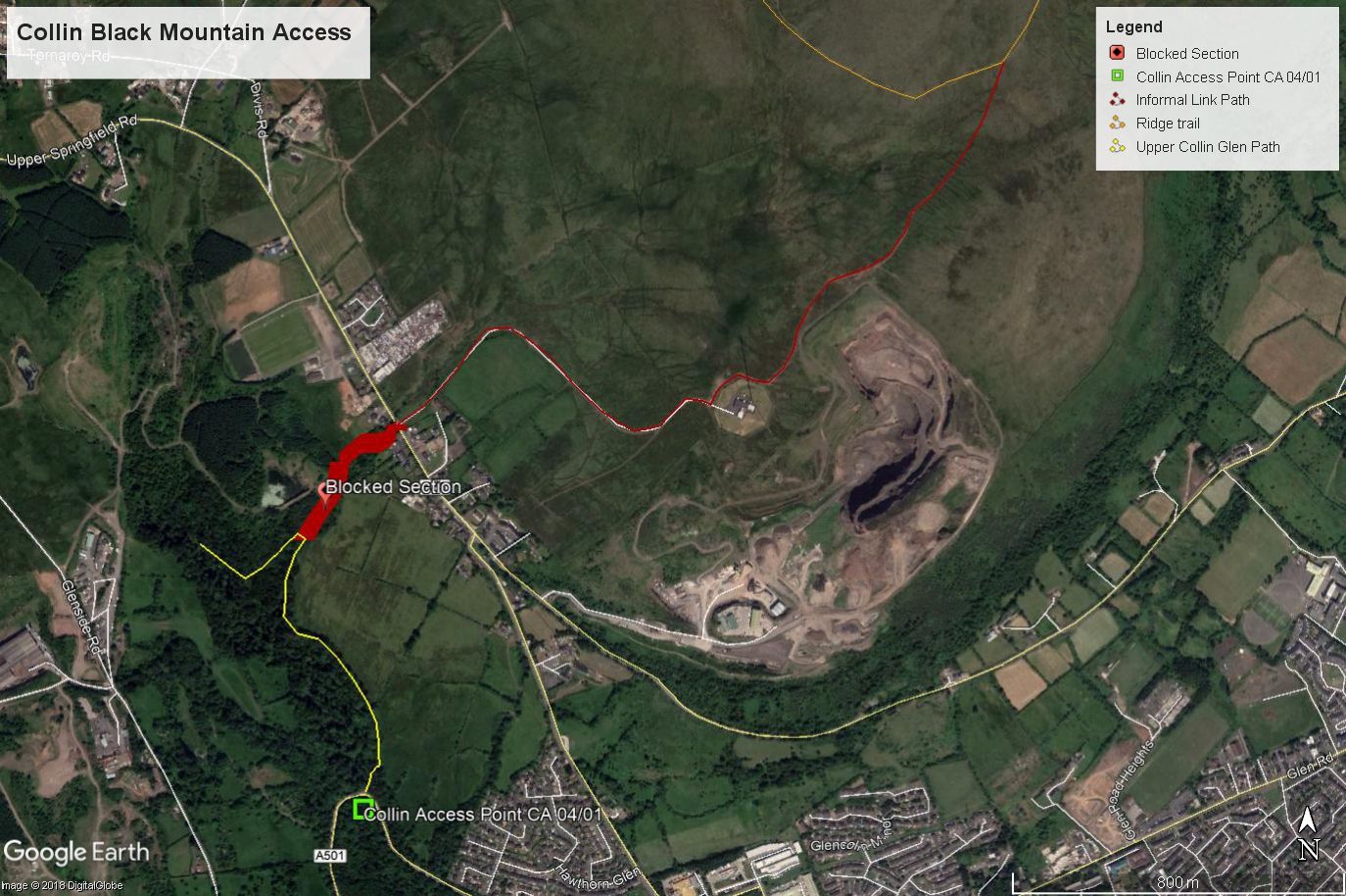
When it comes to connecting Colin Glen to Black Mountain the report recommends revisiting a route that was previously blocked following a change in ownership of the land and nearby quarry in 2013.
If this link is completed direct access to the Black Mountain can be achieved by crossing the Hannahstown Road and proceeding up the road to the UTV transmitter. Beyond that there is a 1km path leading round the edge of the Black Mountain Quarry and linking with the Black Mountain ‘Ridge Walk’ trail. The main entrance to the National Trust property can in any case be reached via a short road walk.
The report also recommends the completion of the Ulster Way with the development of a middle section travelling north from the end of the National Trust property, over Wolf Hill, across the Ballyhill Road and Ballyutogue Road, then over Squire’s Hill and to the Upper Hightown Road entrance to the Cave Hill Country Park.
If completed, the Ulster Way combined with the restoration of the link between Colin Glen and Black Mountain would create a 51km Circuit of Belfast Route which would incorporate the Hills, Belfast Lough, the city centre and Lagan Valley.
While the Connswater Greenway cost £20 million and the Council estimate that the link between Whiterock and Black Mountain would cost £350,000, the Belfast Hills Access Campaign dispute these figures estimate that the work could be completed for a mere £416,000.
The passing of this report comes as the Department for Infrastructure wrote to Belfast City Council outlining how Minister Nichola Mallon is keen to see improved access to the Belfast Hills.
In the letter they said: “The Minister believes that greenways and similar community paths will ultimately create public spaces that will enhance our quality of life and leave an enduring legacy to be enjoyed by future generations. The actual development of greenway projects is, in general terms, the responsibility of local Councils rather than the Department but the Department is keen to work closely with you and other stakeholders to support the development of active travel routes.
“The Minister has committed £20 million for blue/green infrastructure and to working with Councils and other partners in identifying and delivering active travel and greenway projects. £750,000 from that fund has already been allocated for the development of the Forth Meadow Community greenway, which will provide part of an important active travel link to the Belfast Hills.”